


Ali Asghar Mounesan, the head of Iran's Cultural Heritage, Handicrafts and Tourism Organization, has appealed to the first vice president in a letter to exclude Chogha Zanbil and Haft Tappeh, two heritage sites in Khuzestan Province, from the precincts of Shush Special Economic Zone.
The zone covers an area of 300 hectares, encompassing a part of the sites' buffer zones.
For each historical or cultural property, a special territory is defined to provide an additional layer of protection, separate it from other sites and ensure no harm comes to the site. The protected zone is divided into three areas with Zone 1 being the closest to and Zone 3 furthest from the main site.
The heritage sites office at ICHHTO told Financial Tribune that the economic zone is adjacent to the primary buffer zone of Chogha Zanbil and Haft Tappeh.
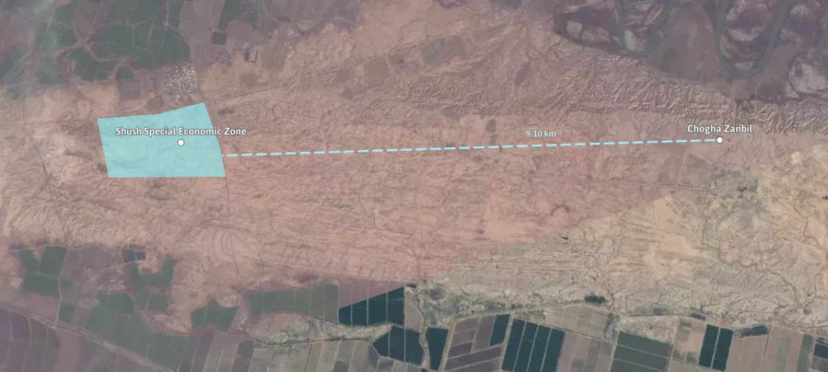
Chogha Zanbil is the world's oldest, best preserved and architecturally unique ziggurat located near the national heritage site of Haft Tappeh, CHTN reported.
In 1979, it became the first Iranian site to be inscribed on UNESCO's World Heritage List.
However, according to the heritage officials, it is likely to lose its global status if the defined area for Shush Special Economic Zone is not modified.
Special economic zones are primarily designated for commercial purposes. Once heritage structures or their defined territories are located inside the zone, their historical value might be overshadowed by business activity while constructions might also endanger them.
The letter, addressed to Es'haq Jahangiri, highlights the rules and regulations set in the Fourth Five-Year Development Plan (2005-09) and tasks ICHHTO with identifying and documenting historical and cultural heritage sites in the proximity of urban or commercial development plans to protect the sites from any probable harm.
In his letter, Mounesan emphasized that "all executive administrations, ministries and state-run organizations must carry out preliminary and feasibility studies in advance of major constructions".
The official voiced his opposition to any illegal construction in the buffer zone of the heritage sites and urged the vice president to undertake negotiations over the modification of the zone's map to "prevent any possible defects to the historical structures and negative impression among the residents".
Shush Facing More Threats
Besides the special economic zone inclusion, a more risky scheme to build an underpass near the UNESCO-inscribed archeological site of Shush, also known as Susa, has also raised concerns among heritage activists and experts.
The Society for Iranian Archeology was the first to object to the plan, asking Minister of Roads and Urban Development Abbas Akhoundi in a letter to stop transgressing the borders of Shush, Mehr News Agency reported.
Reportedly, the plan to convert Shush-Andimeshk Bridge in the city into an underpass was first proposed in 2010.
The plan has been recently launched and inevitably the bridge is being demolished. What can definitely endanger the historical structures is that heavy vehicles and loaders are currently working near the heritage sites' buffer zone.
"The plan seriously endangers the ancient site with irreparable damage," the letter said.
According to official data, the designated territory for the historical city was defined in 1999 and approved by ICHHTO in 2013. Therefore, the regulations should be observed by all administrations.
The archeologists also worried over the safety of the heritage site and warned about the negative impacts such construction activities near the structures could have at the international level.
Covering about 350 hectares, Shush constitutes one of the world's largest archeological sites. It was formed on the bank of Sha'ur River and has been inhabited from the 4th millennium BC until the 8th century.
Along this period, it was the capital of the Elamites and subsequently the Achaemenians for some 2,800 years.
Since about 150 years, the French Archeological Mission and then Iranian archeological teams have carried out excavations there, retrieving artifacts, buildings and objects from various periods, and most importantly, deriving knowledge about Elamite history and culture.

Add new comment
Read our comment policy before posting your viewpoints